
BY Kristina Woods
Lawrence School
Project Description
The Maker Movement combines the “ingenuity ethos with modern technology and innovation.” Specifically, 3D printing brings visualization to difficult concepts such as scale, structure and function. Other difficult concepts include math and graphing, historic artifacts, props in English, and diagram maps and topographical features in geology. For many students, hands-on learning approach enables students to touch and feel the concepts they’re learning, leading to deeper understanding. This can help the abstract become more concrete. Furthermore, 3D printing encourages students to expand their thinking. I have witnessed first hand the effects on stimulating creative solutions, creating more innovative problem solvers in many hands-on projects. With these tools that lend to more Inquiry within the classroom, I need to become the technology facilitator while students become responsible for projects that can only be mastered by actively taking part in the learning. Students get involved what they are doing and end up collaborating while becoming engaged in the lesson.
How will the project be evaluated (e.g. how will you gauge its success)
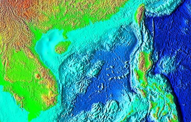
Students will have studied and learned about topographic maps and will be at the point of creating their own maps based on reading topographic maps and translating that information into a 3d – CAD designed three-dimensional map creation that can be printed. So, verifying the accuracy of the 3D design/print and the original topographic map. Also, the process of collaboration, planning, and use of the 3D program will also factor into the success. Students will be using the scientific practices of designing and modeling.
Benefit to the students and the school
In my classes this year, I plan to have one of my classes reproduce fossils and print. We will have these for future years as manipulatives to model concepts.
My other classes will work in groups to create a raised relief map of the world during a new unit on topography. I specifically hope to focus on the ocean floor: trenches, continental shelf, and vents, to name a few. With the change in our curriculum this year due to the adoption of the new MA STE Curriculum Frameworks, we have new content to create. Naturally, this is an inquiry based opportunity that can be differentiated by roles and the chosen locations to map. It’s an inquiry-based STEM project within our new earth science curriculum.
Timeline of Project (when will you do the project, if applicable)
This project will take place beginning in December, when students begin to delve into our earth science/geology curriculum. It is going to take a long time to make a full raised relief map. We will build on it each year until the whole map is created!